Frequently Asked Questions (FAQ)
What is RLID?
How do I access RLID?
What are the system requirements for RLID?
How current are the data in RLID?
Why copy data into a data warehouse like RLID when it already exists in other systems?
Where can I find information about the data available in RLID?
Are other products and services available from LCOG?
When do I get billed?
How do I pay online?
What is the Property Search?
What is RLID Maps?
What is the Deeds & Records Search?
What is Taxes Balance Due?
What is Comp Sales?
What is Taxmap Search?
What is the Lien Search?
What is Taxlot History Search?
How do I search for Permits?
How do I search for CC&R's?
How do I highlight a taxlot and print a PDF map in RLID Maps Pro?
How do I add data in RLID Maps Pro (e.g. add FEMA flood zone and LOMA letter data)?
How do I create a mailing list based on a distance from a property in RLID Maps Pro?
Standard Search
Advanced & Map Search
Tutorial
| What is RLID? | Back to top of page |
The Regional Land Information Database (RLID) is the product of more than 35 years of collaboration among local government agencies in Lane County. It is one of the fruits of the successful partnership of Lane County, the cities of Eugene and Springfield, the Eugene Water & Electric Board (EWEB), Lane Council of Governments (LCOG) and LCOG's extended family of member agencies. The partnership is unique within the State of Oregon and noteworthy on a broader national scale for its long history of successes in the regional development and sharing of geographic information that is fundamental to the workings of government.
RLID has many faces. For the partner agencies it is a framework for interagency collaboration and sharing. It is also a central repository of shared regional data that streamlines access and promotes efficiency. The partners have proven that they can reduce costly and wasteful redundancies in systems acquisitions, data development and maintenance efforts, and specialized human resources. For other public and private agencies throughout the region, RLID is a valued resource and useful set of tools for querying, analyzing, mapping and reporting information within Lane County. For the public it is evidence of their representative governments coming together in meaningful ways to improve both the quality of the information they collect and maintain and the effectiveness with which they apply it in their daily operations.
In 1999, in response to Y2K and associated computer technology changes, a new web-based query and reporting system of the same name (RLID) was developed. The new Internet system provided access to data from a number of mainframe systems that would be retired at the outset of the year 2000. Soon, the RLID web system was made available on a paid subscription basis to new public and private agencies including local commercial users and members of the public. Since then, RLID usage has seen steady growth and subscriber revenues have become increasingly important to funding the continued development of the system. Today, this public-private collaboration enables both government and commercial users to enjoy a valued information resource while, at the same time, enhancing the overall quality of land information in the region.
In summary, RLID is a valuable central data repository that includes an expanding suite of tools for understanding, visualizing and reporting Lane County land records. RLID's continued success is made possible by the long-standing and successful partnerships that promote collaboration and sharing among the region's government agencies as well as the continued support of RLID users whose needs will continue to drive the system's development and future innovation.
| How do I access RLID? | Back to top of page |
RLID is accessible via an intranet for local government users on the regional network. Access for non-partner government and commercial subscribers is via the internet at www.rlid.org. For information on RLID subscription features and costs, click here.
| What are the system requirements for RLID? | Back to top of page |
Users need a web browser and high-speed internet connection to make efficient use of the map and graphics content on the RLID web site.
| How current are the data in RLID? | Back to top of page |
The timeliness of RLID data is dependent on a few factors. First, and most significantly, the data maintenance schedule for the source data varies from one system to another. A real world event can take days or weeks to get into the digital world. Second, the frequency with which the data is transferred to RLID ranges from daily to weekly, depending on the availabilty of the source.
Key data elements are updated in RLID with the following frequency:
- Site addresses (weekly)
- Tax lots and boundary information (weekly)
- Assessor tax account and sales information (daily)
- A&T tax maps and plat maps (weekly)
- Deeds and Records Index and Images (daily)
- Map layers (weekly)
| Why copy data into a data warehouse like RLID when it already exists in other systems? | Back to top of page |
Data are copied into RLID from source systems maintained by the respective member government agencies within the region. Many of these systems do not support external access for security or performance reasons. These systems are also not typically designed to support the kinds of queries RLID supports, making it difficult for some regional users to use the information for their own purposes.
Copying selected data to the RLID data warehouse facilitates integration of the data, making it easier to view information from different jurisdictions and systems. Agency users have the choice of independently accessing the RLID data warehouse through their own applications or using the RLID web applications.
| Where can I find information about the data available in RLID? | Back to top of page |
Look for hyperlinks on selected data fields within RLID reports and also check the information links used throughout the RLID application web pages.
| Are other products and services available from LCOG? | Back to top of page |
Yes! Visit the Geographic Information Systems (GIS) & Data Services area of the LCOG website for details. A number of large format hard copy maps are available for free as downloadable PDF format files. Some of the products and services available through LCOG include the following:
RLID Web Subscription
Since 2000, subscribers have enjoyed online access via their web browsers to a wide array of the best available information on properties in Lane County, Oregon. With the release of RLID v3 subscribers now have more query, analysis, mapping, and reporting options than ever before for exploring regional data. Learn more about this convenient web-based data portal and how you can enjoy the advantages of anytime access to continually updated data from your home or office. Find out more...
Maps
Can't find the custom map you need on the RLID website? LCOG and our government partners provide a wide range of digital and printed maps covering Lane County and the incorporated cities. Free downloadable PDF files are updated periodically and are available for many of our standard maps. Hard-copy maps can be purchased online and are printed at the time of your order. Custom maps are also available online--use the Custom Maps Order Form to specify the content, size, and details that you want. Find out more...
Aerial Photography
Some of the orthophotography seen on the RLID website is available for purchase in a variety of high resolution digital or printed hard-copy formats. Data can be purchased online for standard or custom areas. Use the Custom Data Order Form to specify your custom area of interest. Find out more...
GIS Data
RLID databases include data from the Lane County Regional Geographic Information System (GIS). The Lane Regional Data Center provides selected digital GIS data for use in your own GIS system. Data can be purchased online for Lane County and the incorporated cities. For custom project areas--use the Custom Data Order Form to specify your area of interest. Find out more...
Demographic Information
Looking for custom census and demographic information beyond the latest US Census Bureau data provided in RLID? Lane Council of Governments (LCOG) provides regional coordination and support for US Census Bureau data, local employment files and other population and demographic information. Free downloadable information are available for Lane County and the incorporated cities. Contact us for custom demographic analysis and reporting. Find out more...
Publications
Lane Council of Governments (LCOG) prepares a wide range of publications in support of projects and reporting of information. Check our listing of available information and publications on a variety of topics and geographic areas within Lane County. Many of these offerings are available for free download. Find out more...
Other Sources
See our Regional Links for additional choices for available information. Find out more...
| What is the Property Search? | Back to top of page |
Three Property Search tools are provided enabling users to access and report on extensive property information. Standard searches can be initiated using common property identifiers such as a site address, owner name, map and lot number, or Lane County Assessor tax account number. Advanced property searches can be made using additional characteristics of a particular property or group of properties (e.g., lot size, school district, zoning, or assessed value). Map searches can be made using a map to identify particular properties of interest. In addition, these search tools can be combined to provide flexible options for locating the exact property or properties users want.
Property information is provided in a variety of formats and includes such items as site address, land use, zoning, administrative and political boundaries, environmental conditions, property ownership, land and improvement values, taxes, property sales, and building characteristics. Image information such as tax maps, subdivision plats, partition maps, recorded documents and aerial photography is also provided.
| What is RLID Maps? | Back to top of page |
RLID Maps is an online interactive mapping and query system. The system allows users to explore the Lane County and find information from a map view or from database queries. A wide variety of data can be viewed including aerial photography; terrain, environmental, administrative, political boundary, and tax lot information. Additional features allow users to create custom sets of properties of interest and print maps or export data into other applications. RLID Maps Pro also generates user-specified buffers around properties of interest to select surrounding properties for notification mailings or other property analyses.
| What is the Deeds & Records Search? | Back to top of page |
The Deeds and Records Search provides a lookup index of documents recorded in Lane County and corresponding document images. The index is updated nightly and is a good source of information on recent property transactions and recorded events. Scanned images of recorded documents are typically available from 1994 forward. Recorded information and images can be researched using the following:
- Grantor or grantee name
- Instrument or document number
- Instrument type and year
- Map and tax lot number (Where it exists, as many documents do not have a map/taxlot assigned to them)
| What is Taxes Balance Due? | Back to top of page |
The Taxes Balance Due Application provides a real-time connection to the Lane County Assessor's taxation system for the purpose of calculating taxes owing or outstanding tax balances on specified properties. The application generates a tax report that contains selected Assessor property information and the tax balance as of a user-specified date. This application is not available to all RLID users.
| What is Comp Sales? | Back to top of page |
Three tools are provided to support information gathering for comparable sales including the Residential Comp Sales Tool, Commercial Property Comp Sales, and Vacant Land Sales. Searches are based on "arm's-length transaction" sales as reported by the Lane County Assessor's Office and return results based on how closely properties match selected characteristics of the subject property.
| What is Taxmap Search? | Back to top of page |
The Taxmap Search allows a user to search for and display or download a taxmap including selected archived maps.
| What is the Lien Search? | Back to top of page |
The Lien Search provides current city lien information for selected cities including the cities of Springfield, Florence, and Cottage Grove. The application generates a report containing summary lien information including the assessment payoff amount, interest and penalties as of a user-specified date. In addition, a convenient link is provided to the City of Eugene lien docket for look-up of similar information.
| What is Taxlot History Search? | Back to top of page |
The Taxlot History Search provides a simple look-up utility for records of renumbered Assessor tax maps. Searches include information from the former *ATMAP mainframe application (1992 – 1999) as well as renumberings tracked since 2003.
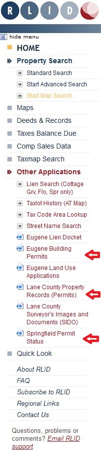
| How do I search for Permits? | Back to top of page |
If a property has a building permit from Eugene it will be listed in the Detailed Property Report (DPR), about halfway down the report. Permits from other jurisdictions, specifically Lane County and Springfield, can be searched for using the links under "Other Applications". If you use one of these external links you will need to enter your search criteria again. We are working on obtaining permit data from all availble sources, as well as integrating it into RLID.
| How do I search for Permits? | Back to top of page |
If a property has a building permit from Eugene it will be listed in the Detailed Property Report (DPR), about halfway down the report. Permits from other jurisdictions, specifically Lane County and Springfield, can be searched for using the links under
"Other Applications". If you use one of these external links you will need to enter your search criteria again. We are working on obtaining permit data from all availble sources, as well as integrating it into RLID.
| When do I get billed? | Back to top of page |
Invoicing occurs at the beginning of each month and represents service for the month being invoiced.
| How do I pay online? | Back to top of page |
You will need to set up an account with Xpress Bill Pay. Once your account is set up, enter your LCOG account name and number to access your eBill.
Lane County, Oregon
